The University of Kansas

Inside Spencer: The KSRL Blog

Books on a shelf

Welcome to the Kenneth Spencer Research Library blog! As the special collections and archives library at the University of Kansas, Spencer is home to remarkable and diverse collections of rare and unique items. Explore the blog to learn about the work we do and the materials we collect.

Throwback Thursday: Air Conditioning Edition

June 28th, 2018

Each week we’ll be posting a photograph from University Archives that shows a scene from KU’s past. We’ve also scanned more than 34,800 images from KU’s University Archives and made them available online; be sure to check them out!

Stay cool out there, Jayhawks!

Photograph of the Chateau Drive-In, 1950s

Chateau Drive-In, 1950s. The restaurant was located at 1802 Massachusetts Street,
where the Dillons grocery store is now. University Archives Photos.
Call Number: RG 71/30 Chateau Drive-In 1950s: Student Activities: Student Hangouts (Photos).
Click image to enlarge (redirect to Spencer’s digital collections).

Caitlin Donnelly
Head of Public Services

Throwback Thursday: Jayhawk Boulevard Edition

June 21st, 2018

Each week we’ll be posting a photograph from University Archives that shows a scene from KU’s past. We’ve also scanned more than 34,800 images from KU’s University Archives and made them available online; be sure to check them out!

Photograph of Jayhawk Boulevard looking east, 1915

Jayhawk Boulevard looking east, 1915. University Archives Photos.
Call Number: RG 0/24/P 1915 Prints: Campus: Panoramas (Photos).
Click image to enlarge (redirect to Spencer’s digital collections).

The photo was likely taken from Marvin Hall.

The buildings from left to right are Strong (east wing only), Bailey, Old Fraser, Old Snow, and Old Haworth. Old Robinson Gymnasium and the Fowler Shops are also visible behind Haworth, to the right. Zoom in and look closely to see a campus streetcar.

Caitlin Donnelly
Head of Public Services

Throwback Thursday: Fishing Edition, Part II

June 14th, 2018

Each week we’ll be posting a photograph from University Archives that shows a scene from KU’s past. We’ve also scanned more than 34,800 images from KU’s University Archives and made them available online; be sure to check them out!

Next Monday is National Go Fishing Day!

Photograph of Dr. James Naismith fishing in Canada, 1936

Dr. James Naismith (left) fishing in Canada, 1936. University Archives Photos.
Call Number: RG 66/22 James Naismith: Athletic Department: Coaches and Staff (Photos).
Click image to enlarge (redirect to Spencer’s digital collections).

Caitlin Donnelly
Head of Public Services

The George F. Jenks Map Collection

June 13th, 2018

Note: A selection of materials from the Jenks collection, including the items shown here, were exhibited in the library’s North Gallery in June-July 2018. An online version of the exhibit is now available.

This past semester I helped process the George F. Jenks Map Collection under the guidance of Spencer Special Collections Librarian Karen Cook. Jenks (1916-1996) taught in KU’s Geography Department from 1949 to 1986, and during his tenure he established a renowned cartography program and became internationally recognized as a preeminent cartographer and scholar. The collection is composed of hundreds of maps, graphics, and associated artwork that he produced for publication and in support of his research. In this post I highlight a few items from the collection to illustrate the scope of Jenks’ career.

Jenks spent much of the 1950s producing statistical maps of Kansas. Representative examples of this work can be found in A Kansas Atlas (1952) and the maps he designed for the Kansas Industrial Development Commission. At a time when most state mapping agencies were either nascent or nonexistent, having a cartographer of Jenks’ caliber proved to be a boon for both the state and private industry. A Kansas Atlas was a rarity upon publication: a multi-color in-depth statistical atlas devoted to a single state. Jenks mapped an exhaustive variety of topics, ranging from population dynamics to agricultural productivity, using a variety of cutting-edge symbolization techniques. It should be noted that Jenks pioneered or fine-tuned many of the map symbolization methods used in this atlas and still in use to this day.

Image of the "center of the nation" map in A Kansas Atlas, 1952

Image of a map of the population of Kansas in A Kansas Atlas, 1952

Image of a map of Kansas mineral resources in A Kansas Atlas, 1952

Selected maps from A Kansas Atlas (1952).
George F. Jenks Map Collection. Click images to enlarge.

The Kansas Industrial Resources atlas (1956) is a masterclass in two-color map design and artful cartographic generalization. Jenks took mundane topics such as railroad freight service and electricity grids and simplified them to create visually arresting, statistically accurate maps. This is no small feat: to this day mapmakers struggle with the challenge of generalizing data so that important information stands out while preserving the accuracy of that information.

Image of the fuel resources map spread in Kansas Industrial Resources, 1956

Image of the fuel resources map spread in Kansas Industrial Resources, 1956

Fuel resources map spread, Kansas Industrial Resources (1956).
George F. Jenks Map Collection. Click images to enlarge.

Generalization was a key theme of Jenks’ research in the 1960s and 1970s. Two of his publications, “Generalization in Statistical Mapping” (1963) and “Class Intervals for Statistical Maps” (1963), remain staples in the cartographic literature. Through this research, Jenks helped to systematize the process for classifying spatial data and devised rules to guide the selection of effective classification methods. The collection contains the maps and graphics Jenks created to illustrate these concepts, many of which are still used in cartography textbooks. Examples from his 1963 articles are below. Also included in the collection are hundreds of the maps he used in in his various generalization experiments.

Image of graphics from “Class Intervals for Statistical Maps,” 1963

Graphics from “Class Intervals for Statistical Maps” (1963) illustrating the
process of data generalization. Different class intervals affect the appearance of the
data on the map. George F. Jenks Map Collection. Click image to enlarge.

Another staple of Jenks’ work are three-dimensional map. Starting in the mid-1960s until the end of his academic career, Jenks refined three-dimensional mapping techniques, first by hand and later using computers. He recognized the potential of representing spatial phenomena in three dimensions, running many experiments and publishing many papers exploring the issue. One publication, “Three Dimensional Map Construction” (1966), remains highly recognizable within cartographic circles, and it also featured one of Jenks’ most famous maps: a three-dimensional representation of population density in central Kansas.

Image of a three-dimensional “smoothed statistical surface” map in the article Three-Dimensional Map Construction, 1966

A three-dimensional “smoothed statistical surface” map representing
population density in central Kansas. This graphic graced the cover of the
November 18, 1966 issue of Science. Jenks originally created this graphic for his
class intervals research. George F. Jenks Map Collection. Click image to enlarge.

This post only skims the surface of Jenks’ celebrated career and barely hints at the contents of the Jenks Map Collection. Readers should keep in mind that while many of the maps featured in this post may not appear noteworthy by today’s standards or software capabilities, they were considered at the cutting edge in their time. Perusing both his personal papers (also maintained at Spencer Research Library) and this map collection reveals the breadth and depth of his cartographic expertise. Jenks was an innovator in many areas; in addition to his aforementioned research interests, he was also recognized as an expert in the areas of curriculum design, cartographic reproduction techniques, and the links between cartography, psychology, and human factors. The Jenks Map Collection preserves a wide assortment of the preliminary and production artwork underpinning his academic and professional careers. The collection finding aid is undergoing finalization and should be published to the Spencer Research Library website in the coming months.

Travis M. White
Special Collections Cartography Intern and 2018 KU graduate (Ph.D., Geography)

References

Jenks, George. (1952). A Kansas Atlas. Topeka: Kansas Industrial Development Commission.

Jenks, George. (October 1956). Kansas Industrial Resources. Topeka: Kansas Industrial Development Commission.

Jenks, G. F. (1963). Generalization in statistical mapping. Annals of the Association of American Geographers, 53(1), 15-26.

Jenks, G. F., Coulson, M. R. C. (1963). Class intervals for statistical maps. International Yearbook of Cartography. 119-134.

Jenks, G. F., Brown, D. A. (November 1966). Three-dimensional map construction. Science. 154(3751), 857-864.

World War I Letters of Milo H. Main: June 11-17, 1918

June 11th, 2018

In honor of the centennial of World War I, this is the second series in which we follow the experiences of one American soldier: twenty-five year old Milo H. Main, whose letters are held in Spencer’s Kansas Collection. On Mondays we’ll post a new entry featuring selected letters from Milo to his family from that following week, one hundred years after he wrote them.

Milo Hugh Main was born in or near Pittsfield, Illinois, on November 21, 1892 to William and Rose Ella Henry Main. The family moved to Argonia, Sumner County, Kansas, in 1901. After his mother died in 1906, Milo remained in Argonia with his father and his two sisters Gladys (b. 1890) and June (b. 1899). His youngest sister Fern (b. 1905) was sent to live with relatives in Illinois.

As Milo reported to the Kansas State Historical Society in 1919, after graduating from high school he worked as a store clerk. He resigned in July 1917 and took a position at Standard Oil Company, possibly co-managing a gas station in Argonia.

Milo entered into military service on September 21, 1917. He served as a wagoner – a person who drives a wagon or transports goods by wagon – in Battery F, 130th Field Artillery. He was stationed at Camp Funston (September-October 1917) and Camp Doniphan (October 1917-May 1918). On May 19, 1918, he boarded the ship Ceramic in New York City and departed for Europe.

Milo wrote this week’s letter from “somewhere in France.” He describes the “country and customs,” especially comparing them with his previous observations of England and contrasting conditions on farms and in cities. “The home boys like all the others in our Battery are enjoying themselves as if they were on their annual vacation,” Milo says. “No reason to be dissatisfied, for we are in the best of health, plenty of good wholesome food, good climate (just a little cooler than Kans), and going thru an experience of a life time.”

Image of Milo H. Main's letter to his family, June 14, 1918 Image of Milo H. Main's letter to his family, June 14, 1918

Image of Milo H. Main's letter to his family, June 14, 1918 Image of Milo H. Main's letter to his family, June 14, 1918

Click images to enlarge.

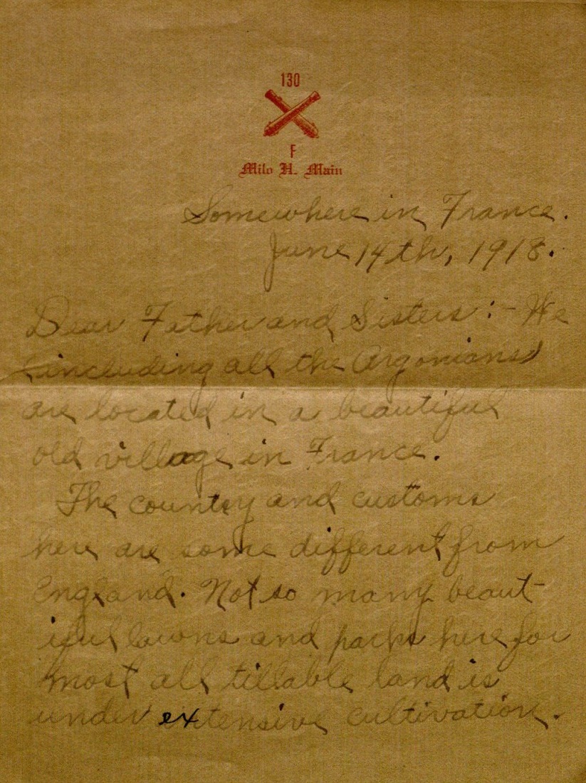
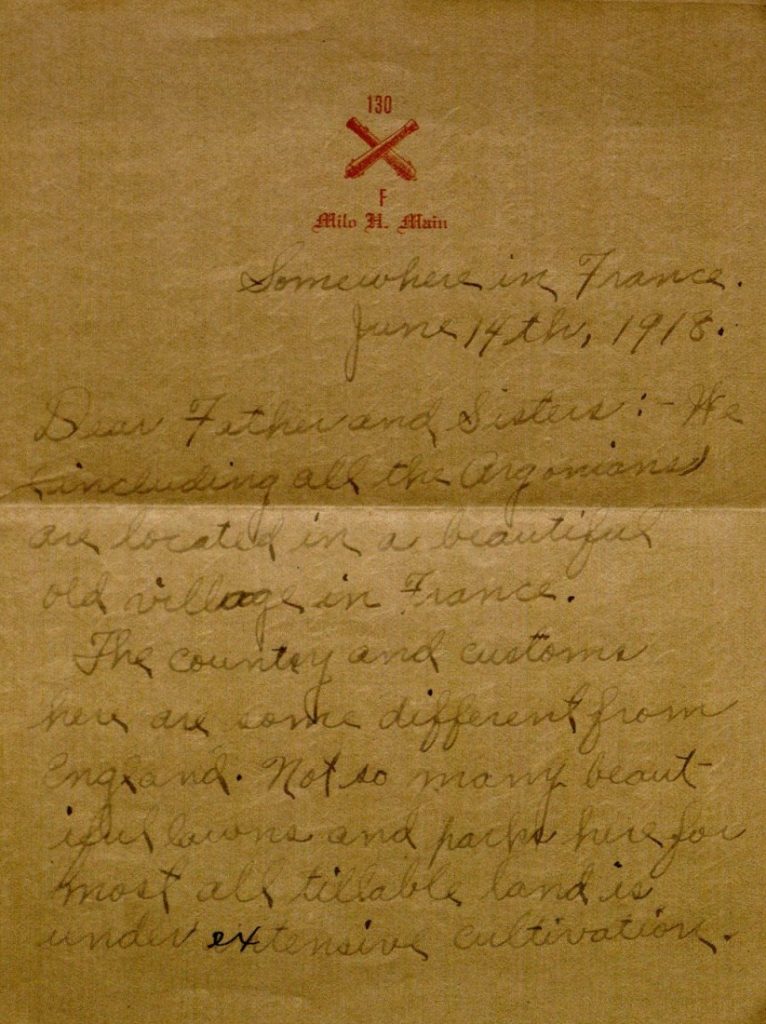
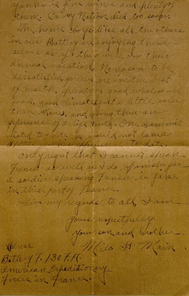
Somewhere in France.
June 14th, 1918.

Dear Father and Sisters: – We (including all the Argonians) are located in a beautiful old village in France.

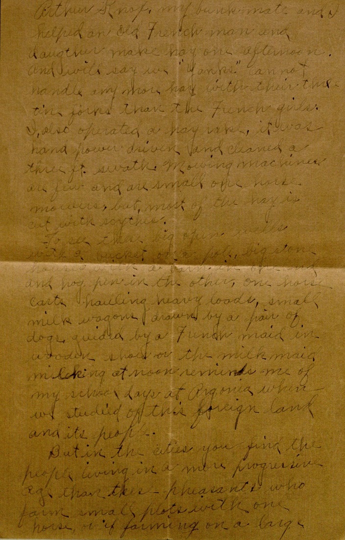
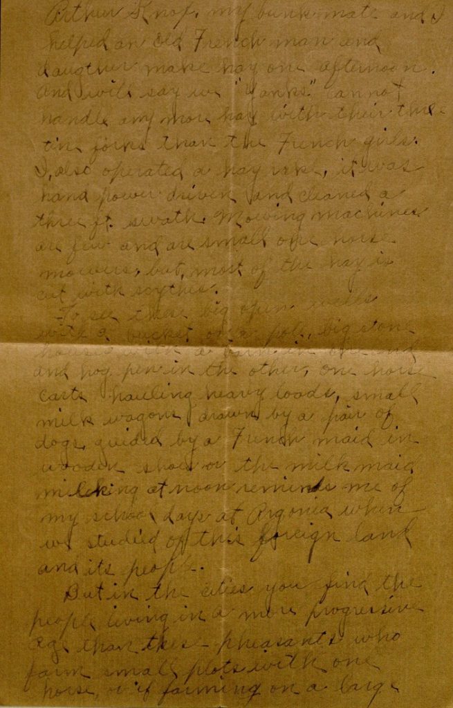
The country and customs here are some different from England. Not so many beautiful lawns and parks here for most all tillable land is under extensive cultivation. Arthur Knox, my bunkmate and I helped an old French man and daughter make hay one afternoon. And will say we “Yanks” cannot handle any more hay with their three tine forks than the French girls. I, also operated a hay rake, it was hand power driven and cleaned a three ft. swath. Mowing machines are few and are small one horse mowers, but, most of the hay is cut with scythes.

To see these big open wells with a bucket on a pole, big stone houses with a barn in one end and hog pen in the other, one horse carts hauling heavy loads, small milk wagons drawn by a pair of dogs, guided by a French maid in wooden shoes or the milk maid milking at noon reminds me of my school days at Argonia when we studied of this foreign land and its people.

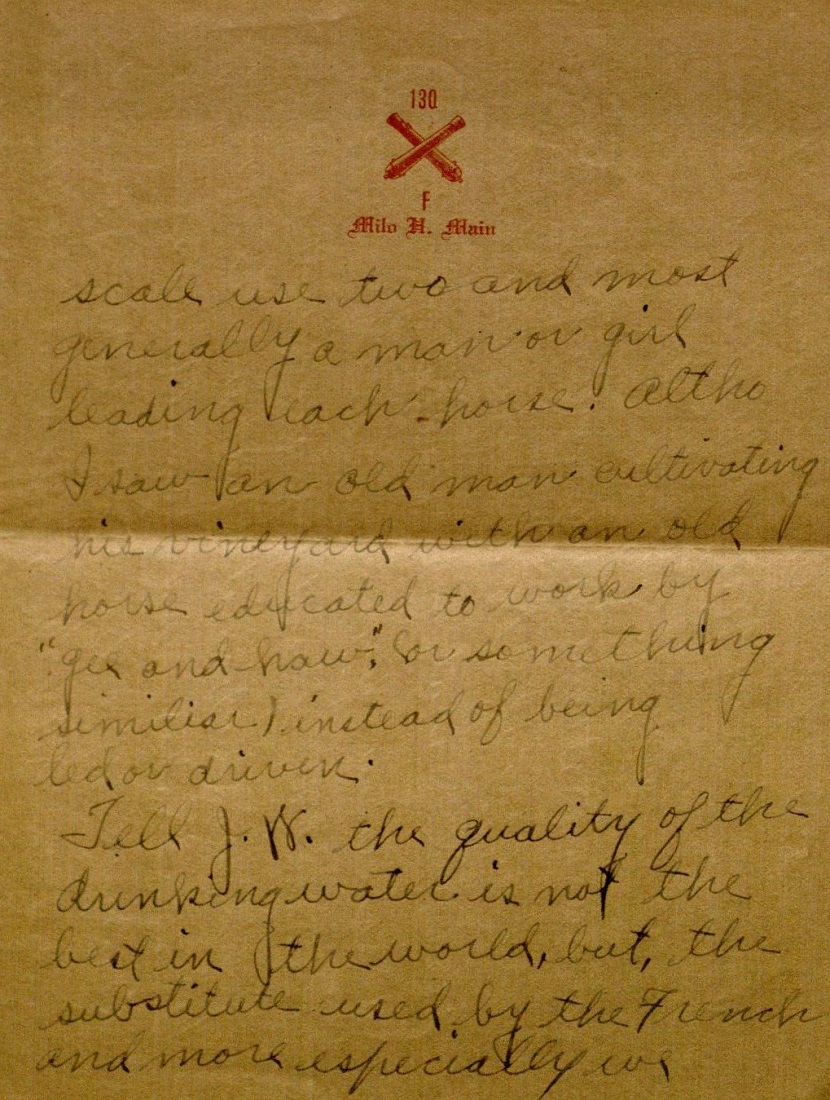
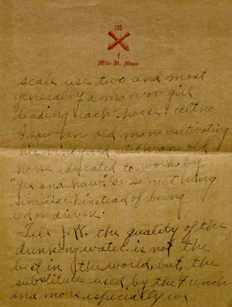
But in the cities you find the people living in a more progressive age than these pheasants who farm small plots with one horse, or if farming on a large scale use two and most generally a man or girl leading each horse. Altho I saw an old man cultivating his vineyard with an old horse educated to work by “gee and haw,” (or something similar) instead of being led or driven.

Tell J.W. the quality of the drinking water is not the best in the world, but, the substitute used by the French and more especially we Yanks is fine wines and plenty of them. Carry Nation died too soon.

The home boys like all the others in our Battery are enjoying themselves as if they were on their annual vacation. No reason to be dissatisfied, for we are in the best of health, plenty of good wholesome food, good climate (just a little cooler than Kans), and going thru an experience of a life time. One Sammie* stated to-nite he would not take a $1000. for his experience to-date.

Only regret that I cannot speak French as well as I do Spanish for a solider speaking French is jake** in this part of France.

Give my regards to all, I am

Yours respectfully.
Your son and brother.
Milo H. Main

Address
Battery F. 130 F.A.
American Expeditionary
Forces in France.

*”Sammie” or “Sammy” was British slang for a U.S. soldier in World War I; it was a reference to Uncle Sam.

**”Jake” was slang meaning “excellent, fine.” From 1914, American English, of unknown origin.

Meredith Huff
Public Services

Emma Piazza
Public Services Student Assistant