That’s Distinctive!: KU Campus Map
June 21st, 2024Check the blog each Friday for a new “That’s Distinctive!” post. I created this series to provide a lighthearted glimpse into the diverse and unique items at Spencer. “That’s Distinctive!” is meant to show that the library has something for everyone regardless of interest. If you have suggested topics for a future item feature or questions about the collections, you can leave a comment at the bottom of this page. All collections, including those highlighted on the blog, are available for members of the public to explore in the Reading Room during regular hours.
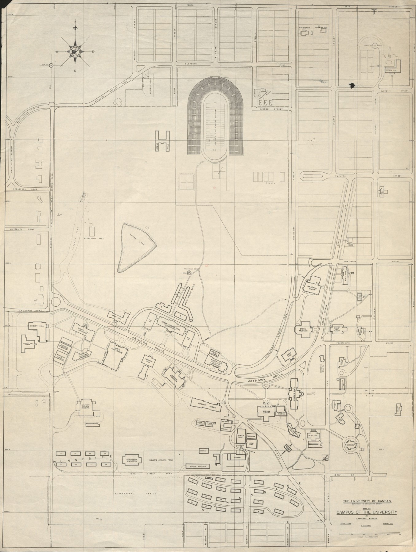
This week on That’s Distinctive! I am sharing a University of Kansas campus map from August 1947. Usually KU related items are housed in University Archives, but this particular map belongs to the Kansas Collection. It was created by Frank A. Russell with contributions by KU’s Department of Engineering Drawing. The map was donated by Clayton Crosier, who has other collections at Spencer Research Library. This includes a collection of photographs and papers in the Kansas Collection and a collection of personal papers related to his time at KU in University Archives. Crosier (1903-1984) received both his bachelor’s and master’s degrees from the University of Kansas. Later, in 1945, he joined KU as a faculty member teaching Applied Mechanics and Civil Engineering. He retired in 1971.
Upon close inspection, one can see that some buildings remain in the same place today while others have moved around quite drastically. Some notable buildings that can still be found in the same location today include the Memorial Union, Spooner Hall (though it is listed as the art museum), and Watson Library. Some buildings that have moved locations include Green Hall and Robinson Gymnasium. Additionally, there are some buildings now on campus that did not yet exist such as Joseph R. Pearson Hall and, most notably, Spencer Research Library. Before the library opened in 1968, several annex buildings occupied the space behind Strong Hall.
Looking at the way campus has changed over time can be interesting given we are so used to the way it is now. As a former religious studies student, I find it interesting that the former religious studies building known as Smith Hall is titled on the map “Bible Chair.” It implies that the building served the same purpose, but the name shifted over time. Smith Hall was slated to be demolished in the 2023 fiscal year, but plans to do so have been postponed. In 2022 the University Daily Kansan (UDK) published an article about initial reactions to the announcement of the potential demolition. Smith Hall has since been added to the University of Kansas East Historic District.
Looking at the map, it is also interesting to think about why buildings moved significantly rather than staying where they were. The ways in which campus has shifted over time tell a story about the needs of the university. Despite all the changes, I hope there is something on the map you find interesting or did not know before.
Tiffany McIntosh
Public Services