The University of Kansas

Inside Spencer: The KSRL Blog

Books on a shelf

Welcome to the Kenneth Spencer Research Library blog! As the special collections and archives library at the University of Kansas, Spencer is home to remarkable and diverse collections of rare and unique items. Explore the blog to learn about the work we do and the materials we collect.

Albert Dwight Searl: A Free-State Surveyor in Bloody Kansas

August 13th, 2019

In 1854 the Kansas-Nebraska Act opened the Kansas Territory for settlement, destined to become a free or a slave state by popular vote. Conflict between settlers from slave-holding Missouri and anti-slavery New England inspired the nickname “Bleeding Kansas.” Although a free-state Kansas constitution was adopted in 1861, the Civil War prolonged the strife until 1865.

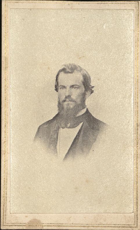
Among the first Kansas settlers were land surveyors needed to lay out land claims and towns. Albert Dwight Searl (1831-1902), a civil engineer from Massachusetts, reached the Lawrence town site in September 1854 with the second group of settlers.

The first group had arrived a month earlier and roughly laid out land claims. As one settler wrote: “After pacing off a half mile square, we drive down a stake at each of the four corners; on one of the stakes we write: I claim 160 acres of the lands within the aforesaid bounds, from the date of claim. This is then copied and taken to the register and recorded.” After Searl arrived they pooled their already staked claims, and he began “to survey farm lots in number equal to the claimants in both parties.” When Searl and an assistant surveyed the Lawrence town site in September, the tall prairie “grass wore out their pants to the knees till they had to cover them with flour sacks for protection.” Searl “established the meridian line …by setting a row of lights up and down Massachusetts Street in the evening and running a line by the North Star.”

Picture of the 1854 Searl Map of Lawrence housed in the Spencer Research Library Lobby

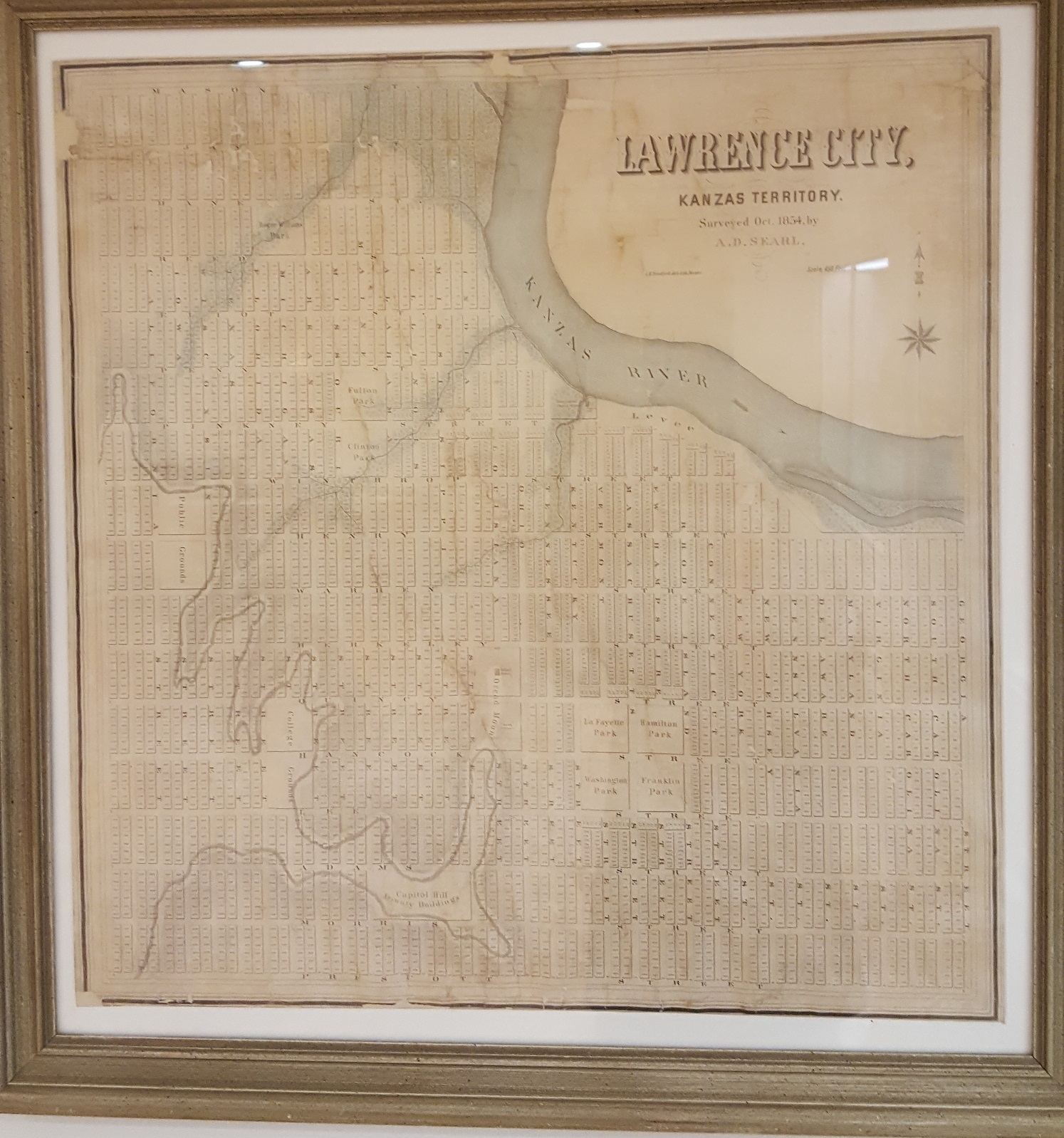
Searl’s plan of Lawrence arrived from the Boston lithographic printer in January 1855. “Map of Lawrence City, Kanzas, Surveyed in Oct. 1854 by A. D. Searl,” which is on display in the Spencer Research Library lobby. Click image to enlarge.
_


An 1869 bird’s eye view shows Lawrence expanding to fill the grid laid out by Searl. University of Kansas, Spencer Research Library call #: RH Map R140

An 1869 bird’s eye view shows Lawrence expanding to fill the grid laid out by Searl.
Ruger, A. Bird’s eye view of the city of Lawrence, Kansas 1869[Place of publication
not identified: Publisher not identified, 1869]. Call Number: RH Map R140. Click image to enlarge.

He also laid out Topeka, Osawatomie, Palmyra and Prairie City. An 1855 newspaper article said, “Mr. Searl … seems to us well qualified for getting up a complete map of Kansas, and we hope he well [sic] be induced to prepare one immediately after the completion of the surveys.” Soon the Territorial Legislature hired Searl to undertake the map project with a partner, Edmund Burke Whitman. They spent a year traveling the Kansas Territory. In April 1856 the local newspaper praised their draft map for including “all rivers and creeks, with their names, main-travelled roads to the various sections, post offices, towns, trading posts, forts, mission stations, Indian reserves, noted mounds, guide meridians, base and township lines.” In May 1856, before the map was published, pro-slavery raiders attacked Lawrence and burned down the Eldridge Hotel, the Free-State headquarters. The views on Searl and Whitman’s 1856 map of Kansas show the Eldridge Hotel newly built in April and as burned ruins after the May raid.

Searl described damage to his own nearby office: “I had among my papers notes of surveys of different parts of the Territory; … I also had notes of the surveys of Lawrence and Topeka … The transit instrument was injured, the axis of the telescope was bent, and the screw that secures the axis to the upright pieces that support the telescope was broken and rendered the instrument unfit for use; … The door of the office was broken open, some window lights broken, two chairs injured; the drawing table besmeared with whisky and sugar, and the house dirtied up by oyster cans, &c.”

Undeterred, Whitman and Searl opened their Emigrant’s Intelligence Office in Lawrence in May 1856. As general land agents they offered to help clients seeking land in Kansas. According to their prospectus, Searl, who had laid out the city of Lawrence, could “trace back all the lots to their original holders, and show the valid titles.” They were also “prepared to lay out town sites and to survey farm claims, – to negotiate the sale and transfer of town property generally, – to investigate the validity of titles, – to superintend the erection of buildings, and to act as Agents for the care of property owned by non-residents.” The partnership was brief, though, and Burke left Kansas in 1858.

However, Searl, his wife and two children remained in Lawrence. In November 1855 he joined a Free-State Army unit, the Kansas Rifles No.1. Short in stature like most of its members, Searl proposed renaming it the Stubbs. The Stubbs saw much action during 1856. In 1861 Searl joined the 8th Kansas Volunteers as a private, later transferring to the 9th Kansas Cavalry and mustering out as a captain in 1865.

From 1866 to 1871 he supervised the construction of a railroad line from Pleasant Hill in northern Missouri to Lawrence, Kansas.

In 1868 Searl and William Fletcher Goodhue, a younger civil engineer also employed in Kansas railroad construction, undertook a detailed map of Lawrence. A newspaper article said the map would measure 4’4” x 5’10” and cover “three miles square, or nine miles of the country in and about Lawrence.” The margins would include 25 to 30 representations of public buildings, businesses, and the better class of private dwellings. Holland Wheeler, then Lawrence City Surveyor, saw and approved a draft. Goodhue was supposed to oversee the lithographic printing, but errors in numbering city lots occurred when copying the map at the printer. Searl rejected the printed maps sent to Lawrence in August 1870. The defective maps were turned over to a local bookseller. Attempts to use the map in land transactions attracted severe criticism of its errors. Wheeler, Searl, and Goodhue responded in print, defending their work and laying the blame on the printer.

In 1866 Searl and Almerin Tryon Winchell, former manager of the Eldridge House Saloon, became partners in a Lawrence billiard parlor and saloon. Still advertising in 1871, they had ceased business by 1875.

From 1874 to 1875 railroad work took Searl to Ohio. By 1877 he was surveying the Denver and Rio Grande Railroad in Colorado. He also undertook Colorado mining ventures. An 1878 visitor commented that the “indefatigable A.D. Searl… and his lop-eared pony have traveled nearly one thousand miles since he came out. … He looks as tough as rubber.”

However, Searl’s family remained in Lawrence, and he returned often. During one visit in July 1881, friends surprised Searl at his Lawrence home to celebrate his 50th birthday. In 1883 his daughter was married in Lawrence, but by 1890 Searl and wife were living in Leadville, Colorado with their children and grandchildren. When Searl died there in 1902, though, his final wish was for burial in Lawrence.

Karen S. Cook
Special Collections Librarian

To learn more and consult citations, please see Karen’s longer article on the subject:

Cook, Karen S. “Partisan Cartographers During the Kansas-Missouri Border War, 1854–1861” in: Liebenberg E., Demhardt I., Vervust S. (eds) History of Military Cartography. Lecture Notes in Geoinformation and Cartography. Springer, Cham. 2016. DOI: https://doi.org/10.1007/978-3-319-25244-5_14

Throwback Thursday: Football Practice Edition

August 8th, 2019

Each week we’ll be posting a photograph from University Archives that shows a scene from KU’s past. We’ve also scanned more than 34,800 images from KU’s University Archives and made them available online; be sure to check them out!

Photograph of a University of Kansas football practice, 1930s
KU football practice, 1930s. University Archives Photos. Call Number: RG 66/14 1930s: Athletic Department: Football (Photos). Click image to enlarge (redirect to Spencer’s digital collections).

This photo was taken approximately where the football team’s current outdoor practice field stands. Mississippi Street is visible on the left. In the background, from left to right, are the Kansas Union, Dyche Hall, and Green (now Lippincott) Hall.

Caitlin Donnelly
Head of Public Services

Historic Kansas Photographs Recently Donated are the Subject of a Temporary Exhibit (Part Two)

August 7th, 2019

This second installment of the temporary exhibit of the Hollmann photograph collection focuses on photographs of Kansas, featuring images depicting settlement, military service, portraits, and colleges. (The first installment highlighted photographs of Lawrence.)

Kansas settlement

Cabinet card of a sod home with family.  Photographer B. I. March

Cabinet card of a sod home with family. Photographer B. I. March.
Call Number: RH PH 536, Box 41, Folder 8. Click image to enlarge.

M. Sheley and his family casually pose outside of their sod home with their horses near Norton. The date of the photograph is approximately 1900. In some areas of Kansas, lumber and trees to build houses were not available to early settlers. They built homes, barns, churches, and schools out of sod instead. Many images of sod structures appear in the Hollmann photograph collection.

Stereoview of Dodge City, Kansas. Published by J. Lee Knight of Topeka, Kansas

Stereoview of Dodge City, Kansas. Published by J. Lee Knight of Topeka, Kansas.
Call Number: RH PH 536, Box 85, Folder 6. Click image to enlarge.

This stereoview shows an early view (1874?) of the settlement of Dodge City. Wagons or carts are piled high with an indiscernible cargo. An inscription on the right side of the card reads “Goods for export, Dodge City.”

Kansas military service

The Hollmann photograph collection contains many images of Kansans serving in the Civil War, Spanish-American War, World War I, and even World War II. Several hundred photographic postcards of Camp Funston illustrate life for Kansans training for World War I.

Postcard of Holyrood men before leaving for Camp Funston. 

Postcard of Holyrood men before leaving for Camp Funston.
Call Number: RH PH 536, Box 15, Folder 34. Click image to enlarge.

This postcard, dated May 27, 1918, captures men in suits leaving their hometown of Holyrood in central Kansas for Camp Funston to serve in World War I. It appears that the photograph was taken near a railroad. The building behind them could be the train station.

Two members of the 9th Cavalry band.  No photographer identified.

Two members of the 9th Cavalry band. No photographer identified.
Call Number: RH PH 536, Box 28, Folder 22a. Click image to enlarge.

Dorcy Rhodes (left) and Sergeant Emilio Jarnilia of the 9th Cavalry band pose outside a building at Fort Riley. Their names are inscribed on the back of photograph. Although their service dates are not identified, the photograph dates from approximately the 1910s.

Kansas colleges

Besides the University of Kansas and Haskell Institute, featured in the previous post, many other Kansas colleges and universities are represented in the Hollmann photograph collection.

Stanley Hall at Western University caption: Western University for African Americans in Quindaro.

Stanley Hall at Western University caption: Western University for African Americans in Quindaro.
Call Number: RH PH 536, Box 44, Folder 16. Click image to enlarge.

Unidentified students stand in front of Stanley Hall at Western University in Quindaro in approximately 1906. The school was established after the Civil War and was the only African American school in Kansas. The university closed in 1943.

Stereoview of the Agricultural College, published by L. A. Ramsour in Manhattan. 

Stereoview of the Agricultural College, published by L. A. Ramsour in Manhattan.
Call Number: RH PH 536, Box 87, Folder 10. Click image to enlarge.

Shown here is the “Main building” of the Agricultural College, now known as Kansas State University, dated approximately 1880. The stereoview publisher, L.A. Ramsour, of Manhattan, Kansas, also published views of New Mexico, hence the publisher’s printing along the sides of the stereoview.

Kansas portraits

Unidentified woman, possibly from Valley Falls.  Photographer McCoy from Valley Falls, Kansas. 

Unidentified woman, possibly from Valley Falls.
Photographer McCoy from Valley Falls, Kansas.
Call Number: RH PH 536, Box 48, Folder 4. Click image to enlarge.

Unfortunately, many of the portraits in the Hollmann photograph collection do not have identification. Often, a penciled inscription on the back of the photograph will identify the subject or give a clue as to the identity. This woman is not identified on the back, however since the portrait was taken in Valley Falls, it is possible that she is from there. Her clothing allows the photograph to be dated to approximately the 1880s.

Carte de visite of Pottawatomie Chief Abram Burnett of Topeka.  The photographers are Bliss & Wentworth of Topeka.  Dated approximately 1869.

Carte de visite of Pottawatomie Chief Abram Burnett of Topeka.
Photographers Bliss & Wentworth of Topeka. Dated approximately 1869.
Call Number: RH PH 536, Box 60, Folder 18. Click image to enlarge.

Pottawatomie Chief Abram Burnett was an important figure in Topeka history, moving to the area in the 1840s and serving as a mediator among the Pottawatomie tribe. He died in 1870 and was buried on his farm.  His grave site is now known as Burnett’s Mound. A note inscribed on the back of the photograph states that the card was purchased as a souvenir in the 1860s.

Be sure to come view the temporary exhibit in the North Gallery in the Spencer Research Library before it closes at the end of August! The Spencer Research Library is open to everyone. If you would like to do research with the Hollmann photograph collection, please see our website for information on visiting and using the collection at Kenneth Spencer Research Library.

Lynn M. Ward
Processing Archivist

Historic Kansas Photographs Recently Donated are the Subject of a Temporary Exhibit (Part One)

August 6th, 2019

Leonard Henry Hollmann from Eudora, Kansas was passionate about photography and collecting photographs, especially those about Kansas or by Kansas photographers.

Mr. Hollmann donated his photographic collection to the Spencer Research Library shortly before he passed away in January 2016. Containing over 10,000 images, the collection is a gem. Hollmann had carefully collected images from across Kansas (and some from Missouri and Nebraska), with a concentration on Lawrence and Douglas County. Most of the images date from the 1850s-1930s.

The collection contains many types of photographic formats including ambrotypes, tintypes, cartes de visite, cabinet cards, postcards, and stereoviews. The arranging and describing of the collection, because of its enormity, took seven months.

This amazing collection is now available for researchers. View the finding aid here: Guide to the Leonard Hollmann photograph collection. At the very top of the finding aid there is a search box where you can enter any keyword to search the document. Try typing in a town name or something else, like “dog” or “bicycle.”

A selection of the Hollmann photograph collection is on exhibit in the North Gallery of the Spencer Research Library until the end of August. The temporary exhibit highlights about 35 images of Lawrence, Kansas and other Kansas towns. The photographs on view date from 1862 to 1918. Some of them are rare and have not been viewed by the public before.

Our two-part blog will feature Lawrence photographs in the first installment and Kansas images in the second installment.

Early Lawrence residents

Ambrotype of deceased 11 month old Lawrence girl, Freddie Rockwell Read, 1862

 Ambrotype of deceased eleven-month-old Lawrence girl Freddie Rockwell Read, 1862.
Call Number: RH PH 536, Box 64, Folder 1. Click image to enlarge.

One of the most defining moments in Lawrence’s history was Quantrill’s Raid in 1863. Before and during the Civil War, Kansas and Missouri had many unofficial skirmishes between each other. William Quantrill’s raid on the free-state town of Lawrence, Kansas (also known as the Lawrence Massacre) was a defining moment in this time period. At dawn on August 21, 1863, Quantrill and his guerrillas rode into Lawrence, where they burned much of the town and killed between 160 and 190 men and boys.

An early type of photograph, ambrotypes were produced by placing a glass negative against a dark background. Although they were more affordable for families, it was uncommon to have an ambrotype photograph taken. Unlike tintypes, only one ambrotype was produced during a photographic sitting. It is possible that this is the first time that this photograph of Freddie Read has ever been published, or been on exhibit!

Carte de visite of John Lewis Crane. Photographer L. M. Price, no location.

Carte de visite of John Lewis Crane. Photographer L. M. Price, no location.
Call Number: RH PH 536, Box 58, Folder 17. Click image to enlarge.

Originally from Connecticut, John Lewis Crane was a partner in a shoe store in Lawrence before he was killed during Quantrill’s raid. Photographs of two of his siblings and brother-in-law Gurdon Grovenor are also in this collection.

University of Kansas

Cabinet card of Hannah Oliver.  Photographer Mettner of Lawrence, Kansas.
Cabinet card of Hannah Oliver. Photographer Mettner of Lawrence, Kansas.
Call Number: RH PH 536, Box 36, Folder 5. Click image to enlarge.

A Quantrill’s raid survivor, Hannah Oliver received her Bachelor of Arts in 1874 and her Master of Arts in 1888 from the University of Kansas. She joined the faculty of KU in 1890, teaching Latin. She retired in 1931. The finding aid for her personal papers at Spencer Research Library can be accessed through this link: Guide to the Hannah Oliver collection.

Stereoview card of Old Fraser Hall, published by W. H. Lamon, of Lawrence, dated 1884.

Stereoview card of Old Fraser Hall, published by W. H. Lamon, of Lawrence, dated 1884.
Call Number: RH PH 536, Box 85, Folder 7. Click image to enlarge.

The “New Building,” as it was called when it was built in 1872, was later called “Fraser Hall” after KU’s second chancellor, General John Fraser. In these images, several covered buggies and horses are visible next to the building. It was demolished in 1965.

The Hollmann photograph collection contains thousands of stereoview cards. These were popular as a form of entertainment from the 1850s to the 1930s. To view the image, the card was inserted into a stereoviewer. When the two separate images depicting left-eye and right-eye views of the same scene are viewed through the viewer, the brain merges both together, creating one three-dimensional image. While stereoview cards in general are common, the cards in the Hollmann photograph collection are mostly of rarer scenes. Some may even be one-of-a-kind.

Haskell Institute

Now known as the Haskell Indian Nations University, images of this important Lawrence school and college are represented in the Hollmann photograph collection.

Tintype of Standing Fox, also known as Ephram Cloud, Junior

Tintype of Standing Fox, also known as Ephram Cloud, Junior.
Call Number: RH PH 536, Box 63, Folder 37. Click image to enlarge.

Little is known of the cased tintype of Standing Fox, also known as Ephram Cloud, Junior. According to paperwork with the image, he may be associated with Haskell Institute.

Cabinet card with identified students of Haskell Institute, photographer J. B. Shane of Lawrence. Students identified on the back as: 1. Geneva Roberts, Wichita (seated, far left); 2. Wiley Morgan, Seminole (standing, on left in back row); 3. Nellie Bates, Wichita (standing, center); 4. Nora Guy, Caddo (in front); 5. Peter Williams, Caddo (standing, on right in back row); 6. Richard Longhat, Caddo (standing, in dark uniform on far right).

Cabinet card with identified students of Haskell Institute, photographer J. B. Shane of Lawrence.
Call Number: RH PH 536, Box 37, Folder 21. Click image to enlarge.

These children have been identified on the back of the photograph as: 1. Geneva Roberts, Wichita (seated, far left); 2. Wiley Morgan, Seminole (standing, on left in back row); 3. Nellie Bates, Wichita (standing, center); 4. Nora Guy, Caddo (in front); 5. Peter Williams, Caddo (standing, on right in back row); 6. Richard Longhat, Caddo (standing, in dark uniform on far right).

Be sure to come view the temporary exhibit in the North Gallery in the Spencer Research Library before it closes at the end of August! Spencer Research Library is open to everyone. If you would like to do research with the Hollmann photograph collection, please see our website for information on visiting and using the collection at Kenneth Spencer Research Library.

Lynn Ward
Processing Archivist

[1]  From Quantrill and the border wars, by William Elsey Connelley, page 367, Spencer Research Library call number RH C5055.

Throwback Thursday: Max Falkenstien Edition

August 1st, 2019

Each week we’ll be posting a photograph from University Archives that shows a scene from KU’s past. We’ve also scanned more than 34,800 images from KU’s University Archives and made them available online; be sure to check them out!

This week’s post features Max Falkenstien, the “Voice of the Jayhawks” who broadcast University of Kansas football and men’s basketball games for sixty years. He died on Monday at age ninety-five.

Photograph of Max Falkenstien with Big Jay, 1996
Max Falkenstien with Big Jay during a halftime ceremony at Allen Fieldhouse, February 4, 1996. The event celebrated Falkenstien’s induction into the KU Athletics Hall of Fame; he was the first member of the media to receive this honor. University Archives Photos. Call Number: RG P/ Max Falkenstien (Photos). Click image to enlarge (redirect to Spencer’s digital collections).

Caitlin Donnelly
Head of Public Services